CHRISTIAN HALSTED

Maps

bike tour map

Shaded relief terrain map created for a class assignment using Adobe Illustrator and Photoshop. (PDF 5.6MB)

turkey population infographic

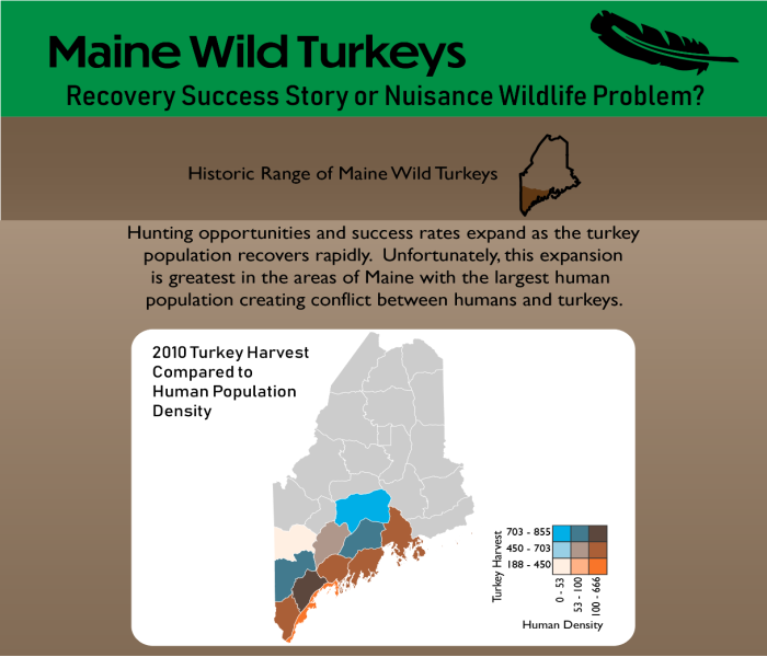
Example of a longform infographic created using Adobe Illustrator. (PDF 0.7MB)

Kittery 100K Bedrock map

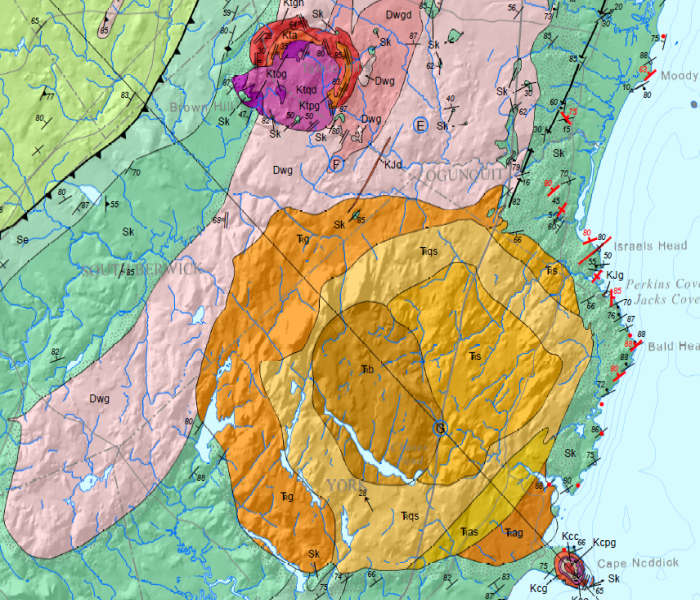
This bedrock map example was created using ArcGIS Desktop. (PDF 20.1MB)

Web Maps

Maine well database map

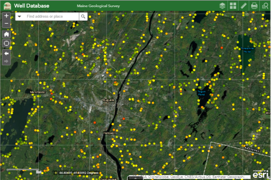
This web map was made using ArcGIS Pro, ArcGIS Online and the Esri Web App Builder. It shows the locations and data for bedrock wells in Maine.

Maine geologic facts and localities map

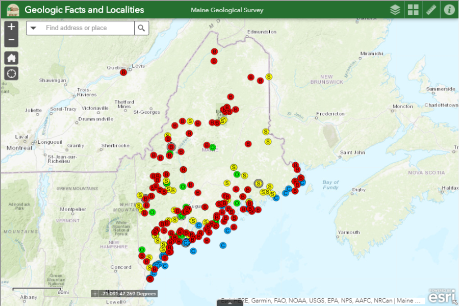
This web page incorporates an ArcGIS Online web map built with the Esri Web App Builder and a DataTable.js table for displaying attribute information.

Kittery 100K Bedrock map

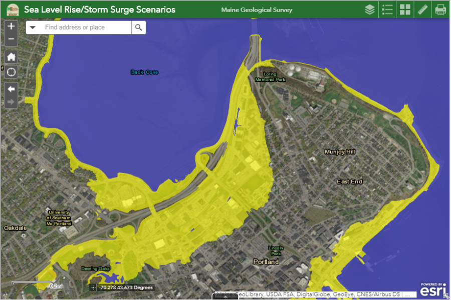
This web map allows you to approximate the potential inland extent of inundation for sea level rise scenarios from 1.2 to 10.9 feet.

MapBox Peanuts theme map

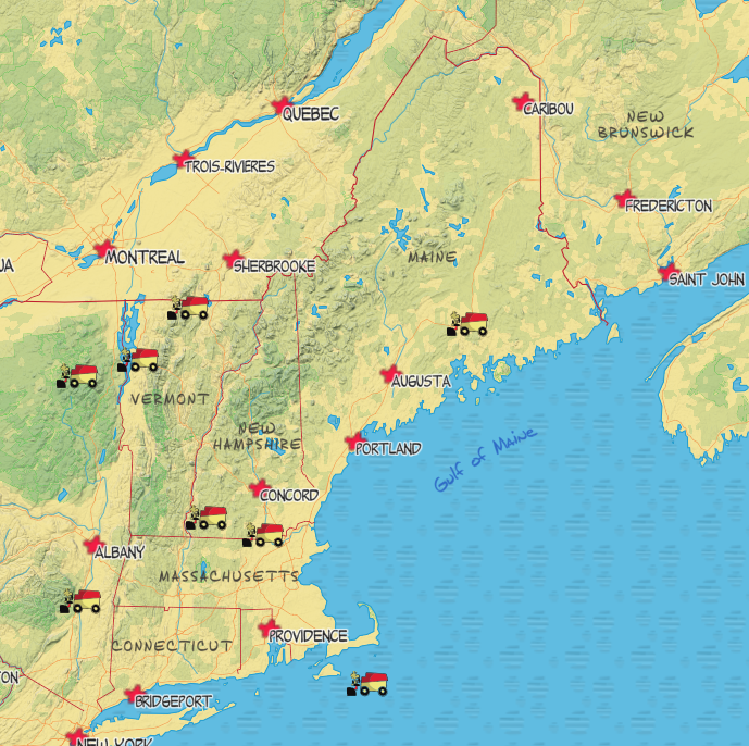
This MapBox Tileset seeks to portray the iconic images and colors of the Peanuts comic strip for the upcoming movie "Snoopy's Hockey Hoopla". The map highlights U.S. ice hockey rinks with Woodstock on the Zamboni. For those traveling to see the movie, or play a hockey game, Snoopy the World War I Flying Ace gets us to the airports and Snoopy's doghouse shows us the way to the hotels. The water texture elicits the feeling of being on the ice - cold steel cutting deep arcs as you streak in on the goalie all alone.

well explorer app

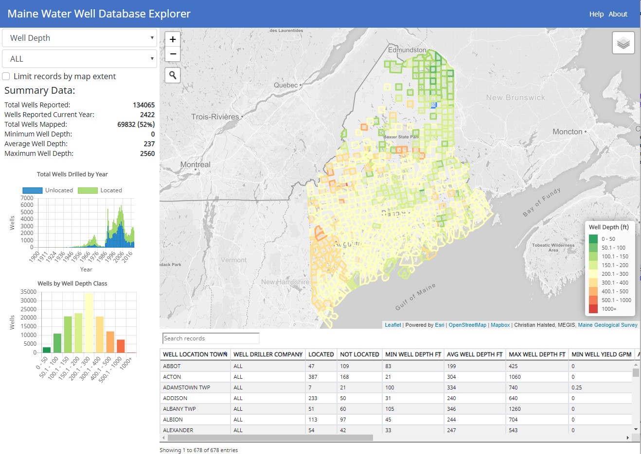
The Maine Water Well Database Explorer is an interactive map visualization tool for tracking key statistics and examining trends for the bedrock wells in reported to the Maine Geological Survey.

Work

MGS logo

Director, Earth Resources Information

Maine Geological Survey, Department of Agriculture, Conservation and Forestry, Augusta, ME

January 2013 to Present

  • Perform GIS map production and spatial analysis with ArcGIS 10.X for 17 geologic map series.
  • Design, test and implement SQL Server database objects using T-SQL for spatial and non-spatial data.
  • Install, administer, evaluate, and upgrade ArcGIS Desktop and SQL Server.
  • Upgrade legacy geologic map production systems from ArcInfo Workstation, coverages and AML to ArcGIS Desktop, enterprise geodatabase and Python.
  • Perform data conversions from legacy systems into enterprise spatial and business databases.
  • Develop exchange, transfer, and load routines for serving and consuming geologic data via data files, data replication and web services.
  • Develop geoprocessing and spatial analysis tools with Python and ArcObjects.
  • Custom Microsoft Access front-end development for SQL Server enterprise databases.
  • Perform spatial data QA/QC using automated and manual processes.
  • Develop, maintain and enhance web site using HTML, CSS, JavaScript, ArcGIS Online, XML, JSON and ReST services.
  • Author and contribute to federal grant applications and technical reports.
  • Develop and implement physical collection and digital data preservation programs.
  • Member of Department Information Services and Technology Committee and Department Web Team.
  • Member of Maine Office of GIS Advisory Council.
state logo

Senior GIS Programmer/Analyst

Maine Department of Environmental Protection, Augusta, ME

April 2002 to December 2012

  • Perform GIS mapping and analysis with ArcGIS 8/9/10 and GPS data collection and post-processing for over 15 programs in the department dealing with hydrogeology, oil and hazardous material clean-up and land, surface water and air regulation or monitoring.
  • Develop geoprocessing and spatial analysis tools with Python and ArcObjects.
  • Perform custom application development with ArcObjects (VBA/VB6) to extend GIS functionality.
  • Develop integration tools that leverage data from environmental sampling, licensing and permitting databases in ArcGIS for mapping and spatial analysis.
  • Act as lead technical contact for all facets of GIS support for over 150 users.
  • Responsible for developing and maintaining bureau spatial database in ArcSDE.
  • Custom Microsoft Access front-end development for Oracle and SQL Server enterprise databases.
  • Integrate Microsoft Access and Excel with VBA as front-end reporting tools for Oracle and SQL Server enterprise database systems.
  • Evaluate, install, test, and deploy new ArcGIS software releases.
  • Perform large and small scale data conversions from distributed systems into enterprise spatial and business databases.
  • Perform spatial data QA/QC using automated and manual processes.
  • Develop MDEP GIS web site to streamline dissemination of spatial and environmental monitoring data using Google Earth.
  • Train staff formally and one-on-one in ArcGIS and field GPS data collection.
Mead logo

Operations Forester

Mead Paper, Shelburne, NH

February 2000-April 2002

  • Oversee all timber harvesting crews, cutting 50,000 cords annually, in New Hampshire District for compliance with job contract specifications, company policies, forest management plans and state laws.
  • Perform harvest job layout, ecological feature identification, and boundary line maintenance.
  • Post-harvest site remediation layout and mapping with GPS and ArcView GIS.
  • Redesign Microsoft Access Forest Management Planning application for Maine/NH Operations.
  • Perform inventory and operational timber cruises.
Champion logo

Procurement Forester

Champion International, Norway, MI

May 1995-November 1999

  • Monitored delivery performance, forestry practices and training and safety compliance for 15 open market pulpwood suppliers delivering 10,000 to 12,000 cords monthly.
  • Coordinated the forest resources and mill woodyard teams in the delivery of 650,000 cords of pulpwood annually, including daily oversight and annual operating plans and budgets.
  • Compiled Forest Land Classification & Ownership database using satellite imagery and MapInfo GIS.
  • Developed Microsoft Access business applications for monthly Supplier Quality Assurance monitoring, Open Market wood ordering processes and Log Concentration Yard scaling and inventory.
  • Member of Mill Pulpwood Scale System Redesign Team and Lake States Region Systems Team.
IP logo

Intern Forester

International Paper Co., Clayton Lake, ME

Summer 1994

  • Performed harvest layout and weekly cutting crew inspections.
  • Created harvest plan database and maps for monitoring and planning of operations.
  • Performed aerial photography layout of herbicide program spray blocks.
  • Conducted site selection, inspection and analysis for pre-commercial thinning trial.
IP logo

Timber Cruiser

Georgia-Pacific Corp., Princeton, ME

Summer 1993

  • Conducted forest inventory using a 2% fixed-radius plot cruise in two person crews.
  • Performed boundary line maintenance, continuous forest inventory plots, and tree planting.
IP logo

Technician

College of Natural Resources, Forestry & Agriculture , Orono, ME

Academic Years 1993-95

  • Generated charts, graphs, and figures with graphics programs for a textbook on conservation biology.
  • Performed hardware setup and software configurations for college-wide Novell network system.

Education

UWisconsin logo
  • University of Wisconsin, Madison, WI (Online), M.S., GIS and Web Mapping, December 2020 (expected)
UMaine logo
  • University of Maine, Orono, ME, B.S., Forest Management with Highest Honors, May 1995
  • 1995 Dwight DeMerritt Scholar, College of Natural Resources, Forestry & Agriculture
  • Xi Sigma Pi Forestry Honor Society, University of Maine
  • Phi Kappa Phi Honor Society, University of Maine

Specialized Training

  • ESRI Instructor Lead Training: Programming ArcObjects with VBA (5 days), Building Geodatabases I (3 days), Introduction to Geoprocessing Scripts using Python (self-study)
  • Visual Basic Programming – 2 Semesters Continuing Education
  • Maine Certified Logging Professional, New Hampshire Professional Logger Program, Michigan Sustainable Forestry Education, Soren Erikksen’s Game of Logging
  • Wilderness & Maine Emergency Medical Technician, CPR, First Aid, Defensive Driving

Memberships

  • Town of Searsmont Planning Board 2018-present
  • Maine GIS Users Group 2002-present
  • New Hampshire Licensed Professional Forester 2000-2003
  • Society of American Foresters 1995-2001
  • USA Hockey Referee 1986-87 and 1998-2016
  • Maine Chapter of the National Ice Hockey Officials Association 2001-2016
  • Eagle Scout, Boy Scouts of America 1990

This isn't a real company but I am a real person. I just thought I would play around with creating a company name and logo for this assignment. I've spent my career helping organizations integrate digital workflows into their business processes. I am a technologist, digital organizer, aggregator, and implementer. My specialty is working with spatial data to enhance and visualize patterns, trends, and real world objects. I focus on database design, geographic information systems, reporting, and web site development. Being elbows deep in rickety datasets all day long isn't glamorous work but the world needs people like me to keep the original works of art and science organized and accessible.

big fish

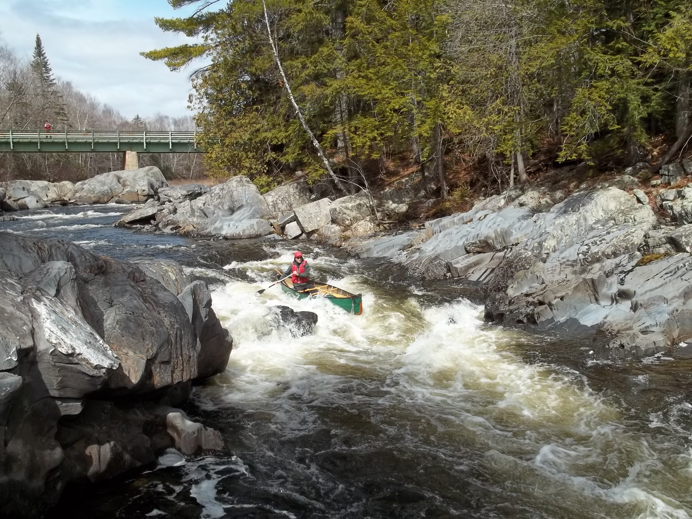
In my spare time, I work to keep our family 'farm' running. We have horses, dogs, goats, cats, chickens, geese, ducks, guniea fowl, a rabbit and some fish. I also manage our woodlot by pruning and harvesting firewood, pulpwood, biomass, and sawlogs to keep our land healthy and productive. When I can get off the farm I enjoy whitewater canoeing, wilderness canoe tripping, hiking, fishing, and hunting.

canoeing